
Connecting the IJ in AT5
Publication
Amsterdam's growth has pushed urban activity beyond its historic center, especially toward the under-connected northern bank of the IJ. Yet the city remains the only European capital to lack a fixed land crossing for cyclists and pedestrians at its historic center. The underdeveloped northern neighborhoods of Amsterdam north, meanwhile, have been facing exponential population growth for decades. With existing ferry or metro crossings for pedestrians and bikes are at breaking point, residents were left to ask the same daily question: how do I cross the river? By 2019, a dedicated land crossing had become a necessity.
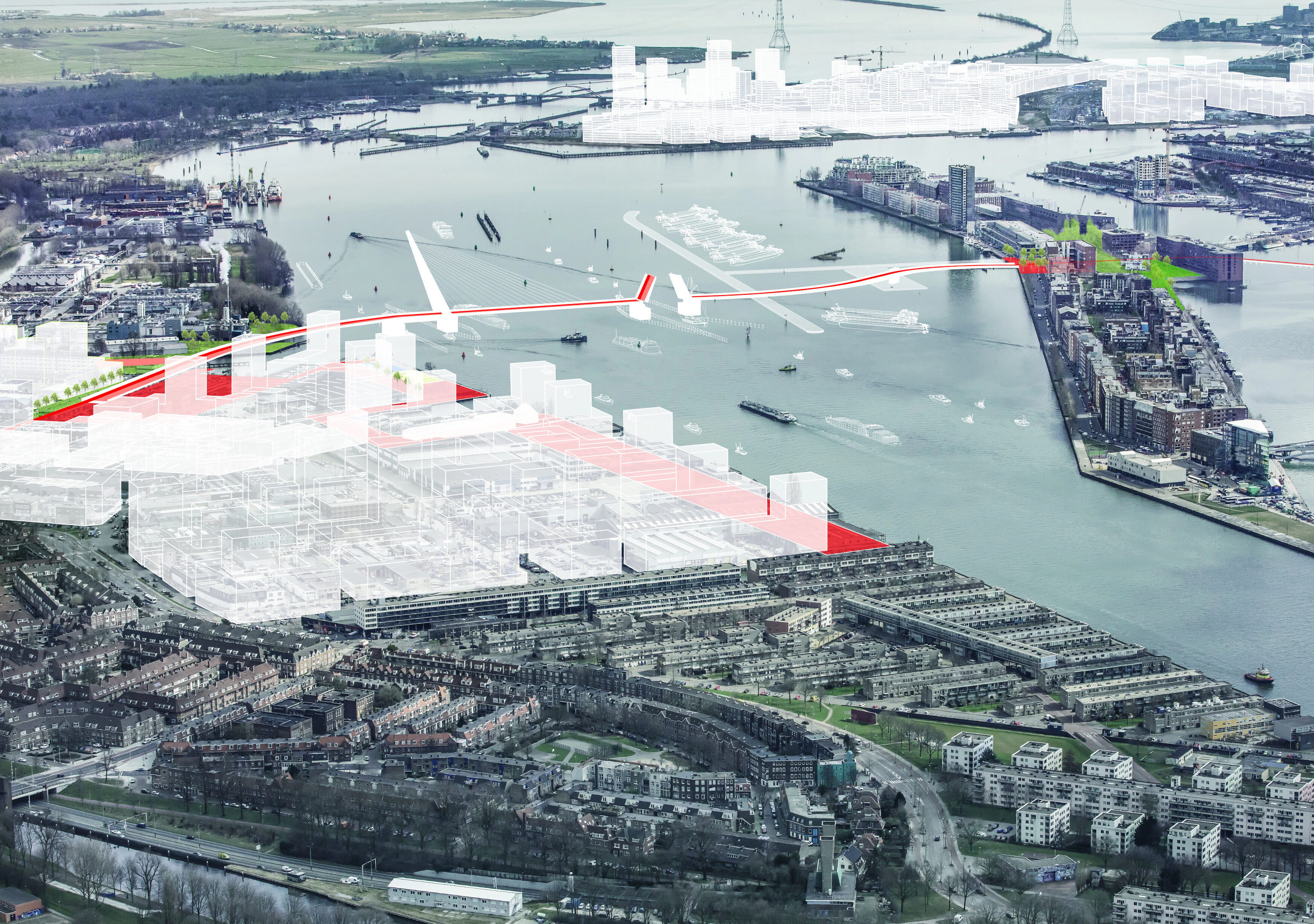
The IJ has long shaped the city's identity as a working waterway, threading commercial ships through the urban core and supporting a vibrant recreational boating culture. But it has also acted as a barrier. For years, municipal and federal authorities had been halted by the same impasse. While the city pushed for bridges to serve its cycling population, river authorities insisted on tunnels to preserve unobstructed shipping lanes. Any crossing strategy would have to accommodate one of Europe’s busiest inland shipping routes, in addition to a fast growing population of cyclists and pedestrians – all without compromising either mode's operational standards.
It would also need to account for two distinct types of river traffic. Commercial shipping requires unobstructed navigation routes. In contrast, Amsterdam’s active recreational boating values flexible access and openness. And finally, the fixed crossings would be expected to align with the city’s tradition of high-quality public space. In other words, the new infrastructure would have to be functional while also enhancing the urban landscape.
Without a breakthrough, however, the northern districts continued to grow. And they remained cut off from the opportunities and services concentrated south of the water.
In 2019, ORG was appointed to chair an independent advisory commission tasked with breaking this deadlock: the Advisory Commission for Shore Connections, led by Alexander d'Hooghe. The assignment was clear: develop evidence-based scenarios that could unite stakeholders around a shared vision for the IJ's future.


ORG launched an independent technical advisory process backed by spatial analysis, stakeholder dialogue and a multidisciplinary team of experts spanning transport planning, hydraulics, hydrology and urban design.
The commission began by working with the river authorities to map all existing shipping routes and infrastructure, identifying the movement of vessels and areas where flexibility might exist.

Equipped with this spatial understanding, the commission then evaluated each potential crossing by testing combinations of bridges, tunnels and hybrid infrastructure against marine logistics, cycling demand, engineering constraints and spatial impact.
The arguments for each were based on extensive technical details to support a clear and fully aligned decision-making process.

Transparent, multi-agency communication helped to maintain political neutrality and credibility throughout the process. All findings and scenarios were presented in accessible formats. By stripping away jargon, we fixed the conversation on the shared goals that united stakeholders: keeping the river navigable, making the city more connected, and ensuring that any intervention would enhance rather than compromise the city landscape.

Delivered in 2020, the commission's final report went far beyond a list of preferred crossing locations. It offers a strategic framework setting out tiered recommendations spanning short, medium and long-term interventions, clear implementation triggers, and design principles to guide future political and financial decision-making.


The scenarios prioritize high-quality cycling infrastructure, recognizing that Amsterdam's future depends on sustaining and expanding slow mobility. At the same time, the proposals respect the IJ's maritime role, ensuring that any crossing whether elevated, submerged, or hybrid would maintain navigation standards and preserve the river's economic function.

Technical specifications aside, the proposed recommendations also prepare the city for the next decades of urban growth in the north. Prioritizing high quality cycling infrastructure without compromising its maritime role, they position the IJ as a connector rather than a divider. And by proposing crossings that integrate seamlessly into the urban fabric and designed with attention to landings, sight lines, and public space, they reframe infrastructure as an opportunity to stitch together communities that had long faced away from one another.

The advisory work provides a foundation for future decision-making, offering both the city and the national government a shared reference point built on evidence rather than institutional positioning or vested interest. As a strategic study, it charts pathways forward for one of the city's most enduring spatial challenges, providing both parties with the tools that transform deadlock into action.

